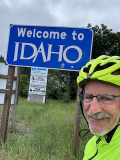
Day 10. IDAHO Clark Fork
62.2 miles 1,919 feet
For my first day in Idaho I had a relatively flat and easy route to Sandpoint. It was cool and cloudy in the morning with a tailwind much of the way, The bridge into Sandpoint has the widest bike lane I've ever seen—about as wide as the 2 car lanes. Click here to see a video. It takes you in to Sandpoint, a very nice water-focused town with lots of restaurants, bike lanes and sports shops. When I think of Sandpoint Idaho I think of the Southern Poverty Law Center articles on white supremacist movements. None of this was apparent in my time there. I had lunch at a Korean BBQ stand and visited 2 very helpful bike shops (in one of which I bought bear spray for dog encounters also),
I continued out of Sandpoint and into a deluge for over an hour. This was not a Pacific Northwest rainstorm but a Rocky Mountain downpour, nonstop. I had Goretex on but my feet and hands were soaked. The good news was that the route was along Lake Pend Oreille (Pond Oray) and relatively flat so despite the rain I kept up a good pace. The shoulder was narrow but I got used to it. Sandpoint was also the place where I switched from Adventure Cycle map #1 to #2. There are 11 maps for the Northern Tier, so by this metric I'm 1/11 of the way! By another metric I'm 492/4200 miles (not including 2 days to get to the start) so I'm about 1/10 the way across the country.
Today's route passed through the site of incredible geological events: the ice dam that formed Glacial Lake Missoula which repeatedly ruptured unleashing the floods that formed much of the landscape of Washington state and Oregon. It's an incredible story, also because the geologist who discovered this history was ridiculed for his (correct) theory. Fortunately the geology world acknowledged he was right during his lifetime. Read more about this here.
Dinner tonight was at the only option: A small bar and grill in Clark Fork where it was Poker Night and the Stanley Cup finals were on the widescreen. People were friendly and very familiar with each other. When an older gentleman came to the bar to my left to pay his bill the bartender said someone else had already paid it for him and added one more beer to the total. He turned to me and chuckled saying his tab included a few beers he bought for friends. We agreed that doing good things for others often gives unanticipated rewards.
Sometimes I'm asked about logging trucks. In my experience, logging truck drivers give me wide berth and pull to the left to pass, sometimes when there isn't much room to the left of the center line, and oncoming cars need to slow. Professional drivers of big trucks in general seem to be very courteous toward me. Most other cars are also. The only exception is the odd pickup speeding by without giving me much room.
People ask also what I think about while biking for so many hours. It is a mixture: when vehicles are passing I am concentrating on staying to the right. At other times I enjoy passing scenery, birdsong, and think some about what to put into this blog. I also think about my progress and miles to go before meal or end of day. So all in all the time passes quickly.
I'm feeling stronger but this is balanced by the work needed to make my strong. At the end of the day I'm very happy to rest.
Amy and I spoke by phone and made tentative plans to meet before Going-To-The-Sun, probably near Kalispel in a week or so. Now I have even more to look forward to!
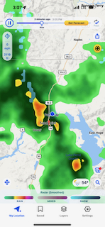
Navigation: I'm a big fan of the Adventure Cycle route both in printed form and on the Bicycle Route Navigator app on my iPhone. The map sections give the route but the app is very useful for making sure I stay on the route. The blue dot shows where I am relative to the route. When traffic seems heavier often there is a turnoff to a quieter road—Adventure Cycle has figured it out.
For my first day in Idaho I had a relatively flat and easy route to Sandpoint. It was cool and cloudy in the morning with a tailwind much of the way, The bridge into Sandpoint has the widest bike lane I've ever seen—about as wide as the 2 car lanes. Click here to see a video. It takes you in to Sandpoint, a very nice water-focused town with lots of restaurants, bike lanes and sports shops. When I think of Sandpoint Idaho I think of the Southern Poverty Law Center articles on white supremacist movements. None of this was apparent in my time there. I had lunch at a Korean BBQ stand and visited 2 very helpful bike shops (in one of which I bought bear spray for dog encounters also),
I continued out of Sandpoint and into a deluge for over an hour. This was not a Pacific Northwest rainstorm but a Rocky Mountain downpour, nonstop. I had Goretex on but my feet and hands were soaked. The good news was that the route was along Lake Pend Oreille (Pond Oray) and relatively flat so despite the rain I kept up a good pace. The shoulder was narrow but I got used to it. Sandpoint was also the place where I switched from Adventure Cycle map #1 to #2. There are 11 maps for the Northern Tier, so by this metric I'm 1/11 of the way! By another metric I'm 492/4200 miles (not including 2 days to get to the start) so I'm about 1/10 the way across the country.
Today's route passed through the site of incredible geological events: the ice dam that formed Glacial Lake Missoula which repeatedly ruptured unleashing the floods that formed much of the landscape of Washington state and Oregon. It's an incredible story, also because the geologist who discovered this history was ridiculed for his (correct) theory. Fortunately the geology world acknowledged he was right during his lifetime. Read more about this here.
Dinner tonight was at the only option: A small bar and grill in Clark Fork where it was Poker Night and the Stanley Cup finals were on the widescreen. People were friendly and very familiar with each other. When an older gentleman came to the bar to my left to pay his bill the bartender said someone else had already paid it for him and added one more beer to the total. He turned to me and chuckled saying his tab included a few beers he bought for friends. We agreed that doing good things for others often gives unanticipated rewards.
Sometimes I'm asked about logging trucks. In my experience, logging truck drivers give me wide berth and pull to the left to pass, sometimes when there isn't much room to the left of the center line, and oncoming cars need to slow. Professional drivers of big trucks in general seem to be very courteous toward me. Most other cars are also. The only exception is the odd pickup speeding by without giving me much room.
People ask also what I think about while biking for so many hours. It is a mixture: when vehicles are passing I am concentrating on staying to the right. At other times I enjoy passing scenery, birdsong, and think some about what to put into this blog. I also think about my progress and miles to go before meal or end of day. So all in all the time passes quickly.
I'm feeling stronger but this is balanced by the work needed to make my strong. At the end of the day I'm very happy to rest.
Amy and I spoke by phone and made tentative plans to meet before Going-To-The-Sun, probably near Kalispel in a week or so. Now I have even more to look forward to!
Navigation: I'm a big fan of the Adventure Cycle route both in printed form and on the Bicycle Route Navigator app on my iPhone. The map sections give the route but the app is very useful for making sure I stay on the route. The blue dot shows where I am relative to the route. When traffic seems heavier often there is a turnoff to a quieter road—Adventure Cycle has figured it out.
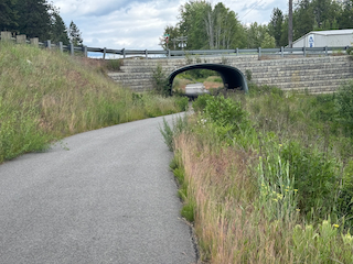
The beautiful Serenity Lee Trail leading into Snadpoint
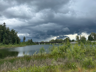
Red zone deluge awaits
